


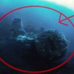


A paranormal YouTube channel named “Flat Earth Arabic” published a video which depicts a huge underwater wall settled beneath the oceans of our planet found on Google Earth.
It is not the first time though. Many UFO pursuers have reported various unexplained objects on Google Earth.
The channel makes a shocking claim that the wall locates miles beneath the ocean.
Since Google Earth started operating, people have become more and more curious to find mysterious things hidden within the borders of our planet.
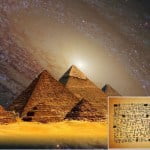
Namely, one researcher found an enormous underwater pyramid in Mexico 12°8’1.5″N, 119°35’26.4″W.
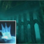
The mysterious towers, sunken lost cities, pyramids and other things are definitely challenging and perhaps altering our history.
Last year, a teenager, with the help of Google Earth, found something that turned out to be one of the biggest ancient cities. This city wasn’t revealed until that moment. Researchers later concluded the city belongs to the ancient Mayas.
The entertaining nature of the pyramids surely makes them one of the top things to search for. Researchers from all over the Earth are looking for them constantly.
In 2012, Angela Micol, using a satellite, found Pyramids that were bigger than the legendary ones that are located on the Giza Plateau.
Moreover, in 2016, explorers discovered a whole complex of formations with an incredible length of 76 miles.
Not only this but also researchers have found mysterious buildings on the coast of Baja California.
Their strange yet unique appearance made a lot of people to believe these formations are only part of the many underwaters.
However, these findings can’t even compare with what was found recently. The amazing underwater wall we previously mentioned doesn’t seem to be natural due to its size and attachment to linearity.
If you try to zoom the coordinates, you will notice an enormous formation. And then immediately the question pops up. Who in the world could ever build such a formation?
Many people don’t consider this wall to even be a real underwater wall. They rather think it’s a Google Earth glitch.
Google Earth employs different pictures when creating planet maps. Thus, it is very likely fragments not to match and to result in an enormous wall.
One of the most rational explanations for this incredible finding is that we see a digital union in the Poles’ mapping.
What is Image Stitching Error?
The method of making a mixture of many images with overlapping fields of view in order to create a panorama or a good image.
Image stitching is helped by a computer software. The approach that experts use usually needs the same overlap between images to get a quality finish.
Nowadays, people use image stitching very often. Google Earth uses it as well.
There are many things that can create an effect of “a wall circling our planet.” It may have been induced by the point of view, illumination, reference, etc.